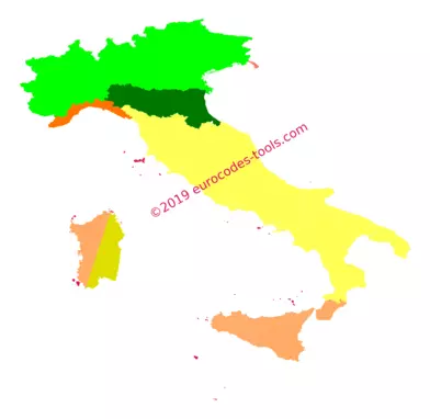
What are the Italian wind zones according to Eurocode 1 (UNI EN 1991-1-4/AN) ?
On the map of the national annex, the Italian area is divided by region (and sometimes by province) into nine wind zones identified from 1 to 9. The islands (with the exception of Sicily and Sardinia) and open sea form zone 9.
| Zone | 1 | 2 | 3 | 4 | 5 | 6 | 7 | 8 | 9 |
|---|---|---|---|---|---|---|---|---|---|
| Fundamental value of the basic wind velocity vb,0 | 25m/s | 25m/s | 27m/s | 28m/s | 28m/s | 28m/s | 28m/s | 30m/s | 31m/s |
| Increased wind velocity above elevation a0 | 1000m | 750m | 500m | 500m | 750m | 500m | 1000m | 1500m | 500m |
How to adjust the basic wind velocity for each direction of wind and according to return period in Italy ?
\[\displaystyle v_{b} = c_{prob} \cdot c_{dir} \cdot v_{b,0}\]- A variation have to be considered with the probability factor Cprob.
- No reduction can be considered with the directionnal factor Cdir=1.0.
- You should also take in account the effect of the roughness of the terrain (vegetation / urbanization) and the effect of orography (terrain relief) to accurately determine the peak velocity pressure for each wind direction.
Which are the terrain categories in Italy ?
In Italy, the exposure categories are calculated from :
- the four roughness classes identified from D to A
- the distances to the shorelines
- the elevation of the relevant site
Roughness classes
0 :
Area free of obstacles (open countryside, airports, agricultural areas, pastures, swampy or sandy areas, snowy or icy surfaces, sea, lakes, …)
I :
Areas with widespread obstacles (trees, houses, walls, fences, …); areas with roughness not attributable to classes A, B, D.
II :
Area with low vegetation such as grass and isolated obstacles (trees, buildings) with separations of at least 20 obstacle heights.
IV :
Area in which at least 15% of the surface is covered with buildings and their average height exceeds 15m.
Exposure categories for each wind zones
| Zones 1 to 5 | ||||||||||||||
|---|---|---|---|---|---|---|---|---|---|---|---|---|---|---|
| Distance to the shoreline | from -2 km to 0 km | from 0 km to 10 km | from 10 km to 40 km | more than 10 km | ||||||||||
| Elevation | – | from 0 m to 500 m | from 500 m to 750 m | more than 750 m | ||||||||||
| A | – | IV | IV | V | V | V | ||||||||
| B | – | III | III | IV | IV | IV | ||||||||
| C | – | * | III | III | IV | IV | ||||||||
| D | I | II | II | II | III | ** | ||||||||
| *Category II in zone 1 to 4, category III in zone 5. | ||||||||||||||
| **Category III in zone 2 to 5, category IV in zone 1. | ||||||||||||||
| Zone 6 | ||||||||||||||
|---|---|---|---|---|---|---|---|---|---|---|---|---|---|---|
| Distance to the shoreline | from -2 km to 0 km | from 0 km to 10 km | from 10 km to 40 km | more than 10 km | ||||||||||
| Elevation | – | from 0 km to 500 km | more than 500 km | |||||||||||
| A | – | III | IV | V | V | |||||||||
| B | – | II | III | IV | IV | |||||||||
| C | – | II | III | III | IV | |||||||||
| D | I | I | II | II | III | |||||||||
| Zones 7 and 8 | Zone 9 | |||||||||||||
|---|---|---|---|---|---|---|---|---|---|---|---|---|---|---|
| Distance to the shoreline | from 2 km to 0.50 km | from -0.5 km to 0 km | on land | Distance to the shoreline | at sea | on land | ||||||||
| A | – | – | IV | A | – | I | ||||||||
| B | – | – | IV | B | – | I | ||||||||
| C | – | – | III | C | – | I | ||||||||
| D | I | II | * | D | I | I | ||||||||
| *Category II in zone 8, category III in zone 7. | ||||||||||||||
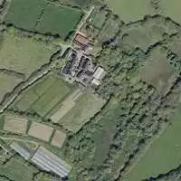
Example of results given by the software Eurocodes Zoning
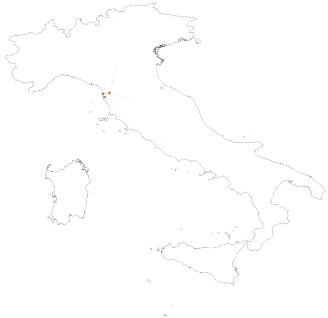
B1 – Localization
- Coordinates in World Geodetic System 1984 (WGS84) 10.5188° , 43.7455°
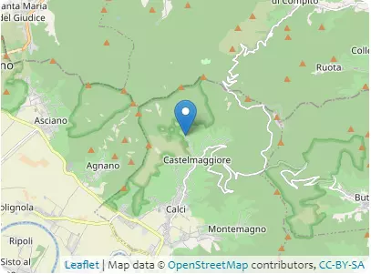
Address 56011 Calci, Toscana
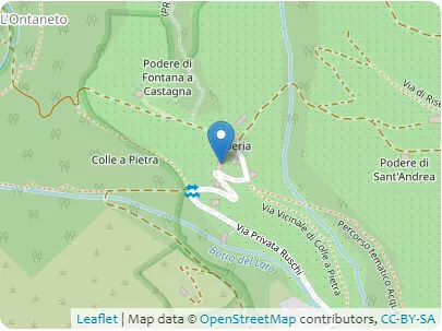
B2 – Elevations
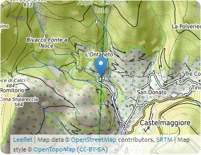
| Coordinates | 10.5181°, 43.7303° | 10.5198°, 43.7596° | 10.5198°, 43.7596° | 10.5179°, 43.7901° |
|---|---|---|---|---|
| Elevations | 60m | 798m | 798m | 109m |
| Obstacle effective height H | 738m | 689m | ||
| Slope actual length Lu / Ld | 3261.4m | 3379.8m | ||
| Slope angle Φ | 22.6% | 20.4% | ||
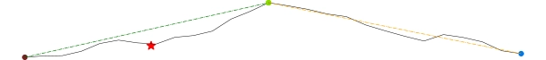
| Horizontal distance site/top x | 1571.5m | |||
| Elevation at the place of construction | 216m | |||
B3 – Building
- Type of building: monumental building
- Design working life category: 50 years
- Max height: 10m
- Orientation from North: 15°
B4 – Terrain categories
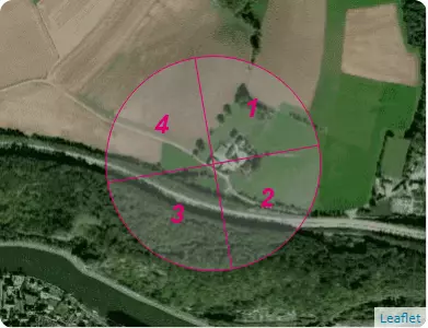
| Sectors | 1 | 2 | 3 | 4 |
|---|---|---|---|---|
| Categories | C | C | B | B |
| Sectors | 1 | 2 | 3 | 4 |
|---|---|---|---|---|
| Sector definition | from 330 ° to 60 ° | from 60 ° to 150 ° | from 150 ° to 240 ° | from 240 ° to 330 ° |
| Distance to shore | > 100 km | > 100 km | 21.3 km | 19.5 km |
| Exposure category | III | III | III | III |
C1 – Snow
UNI EN 1991-1-3 Appendice nazionale 24/09/2010
- Zone : III(sk,0 = 0.6 kN/m²)
- Criteria for zoning : Pisa, Toscana
- Characteristic value of snow on the ground at the relevant site : sk,216 = 0.613 kN/m²
- Ground snow load with a return period of 50 years : s50 ans = 0.613 kN/m²
C2 – Wind
UNI EN 1991-1-3 Appendice nazionale 24/09/2010
- Zone : 3(vb,0 = 27.0 m/s)
- Criteria for zoning : Pisa, Toscana
| Sectors | 1 | 2 | 3 | 4 |
|---|---|---|---|---|
| Sector definition | from 330 ° to 60 ° | from 60 ° to 150 ° | from 150 ° to 240 ° | from 240 ° to 330 ° |
| Value of the basic wind velocity from the map vb,0 | 27.0m/s | |||
| Elevation above which wind velocity increases vb,0 | 500m | |||
| Fundamental value of the basic wind velocity vb,0 | 27.0m/s | |||
| Shape parameter K | 0.138 | |||
| Exponent n | 1 | |||
| Annual probability of exceedence p | 0.02 | |||
| Probability factor cprob | 1.0 | |||
| Directional factor cdir | 1.0 | 1.0 | 1.0 | 1.0 |
| Basic wind velocity vb | 27.0m/s | 27.0m/s | 27.0m/s | 27.0m/s |
| Reference roughness length z0,II | 0.05m | |||
| Roughness length z0 | 0.1m | 0.1m | 0.1m | 0.1m |
| Terrain factor kr | 0.2 | 0.2 | 0.2 | 0.2 |
| Height above ground z | 10.0m | |||
| Minimum height zmin | 5.0m | 5.0m | 5.0m | 5.0m |
| Roughness factor cr(z) | 0.921 | 0.921 | 0.921 | 0.921 |
| Obstacle type | isolated hills | |||
| Exposure type | downwind | – | upwind | – |
| Factor depending on the type and dimensions of the obstacle s max | 0.444 | 0.0 | 0.282 | 0.0 |
| Orography factor * co(z) | 1.181 | 1.0 | 1.128 | 1.0 |
| Mean wind velocity vm(z) | 29.4m/s | 24.9m/s | 28.0m/s | 24.9m/s |
| Turbulence factor kl | 1.0 | 1.0 | 1.0 | 1.0 |
| Standard deviation of the turbulence σv | 5.4m/s | 5.4m/s | 5.4m/s | 5.4m/s |
| Turbulence intensity Iv(z) | 0.184 | 0.217 | 0.193 | 0.217 |
| Air density ρ | 1.25kg/m3 | |||
| Exposure factor ce(z) | 2.706 | 2.138 | 2.532 | 2.138 |
| Peak velocity pressure qp(z) | 1233.0N/m2 | 974.0N/m2 | 1153.8N/m2 | 974.0N/m2 |
| Peak wind velocity for Serviceability Limit States vp(z),SLS | 159.9km/h | 142.1km/h | 154.7km/h | 142.1km/h |
| Peak wind velocity for Ultimate Limit States vp(z),ULS | 195.8km/h | 174.1km/h | 189.4km/h | 174.1km/h |