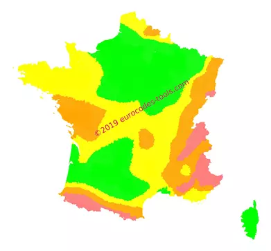
What are the French seismic zones according to Eurocode 8 (NF EN 1998-1/NA) ?
In France, the division is specified in the law (not in the national annex). The French metropolitan area is divided into four seismic zones identified from 1 to 4 (The map below was created from this data).
| Zone | 1 | 2 | 3 | 4 |
|---|---|---|---|---|
| Seismicity | Very low | Low | Moderate | Medium |
| Seismicityagr | 0.4 m/s2 | 0.7 m/s2 | 1.1 m/s2 | 1.6 m/s2 |
The French overseas departments, overseas territories and overseas collectivities each have a specific seismicity.
| Zone | French Guiana | Reunion Island | Mayotte Island | Martinique Island | Guadeloupe Island |
|---|---|---|---|---|---|
| Seismicity | Very low | Low | Moderate | Strong | Strong |
| Reference peak ground acceleration on rock >agr | 0.4 m/s2 | 0.7 m/s2 | 1.1 m/s2 | 3.0 m/s2 | 3.0 m/s2 |
| Zone | Saint Pierre and Miquelon | New Caledonia | Wallis and Futuna | Saint Martin | Saint Barths |
|---|---|---|---|---|---|
| Seismicity | Very low | Moderate | Strong | Strong | Strong |
| Reference peak ground acceleration on rock >agr | 0.4m/s2 | 1.1m/s2 | 3.0m/s2 | 3.0m/s2 | 3.0m/s2 |
Is my new building concerned ?
You can check if your building is concerned on the french regulations on LEGIFRANCE.
Here is the summary:
| Zone/Importance class | Normal risk | Special risk | |||
|---|---|---|---|---|---|
| I | II | III | IV | ||
| Zone 1 | No | Yes | |||
| Zone 2 | No | Yes | |||
| Zone 3 | No | Yes | |||
| Zone 4 | No | Yes | |||
| Zone 5 | No | Yes | |||
Example of results given by the software Eurocodes Zoning
B1 – Localization
- Coordinates in World Geodetic System 1984 (WGS84) 3.5332°, 45.7153°
- Coordinates in French Geodetic System 1993 (Lambert 93) 741482m, 6512993m
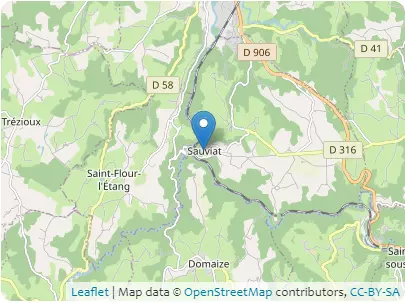
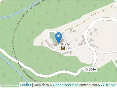
Address D 304A, 63120 Sauviat, Auvergne-Rhône-Alpes
B2 – Altitudes
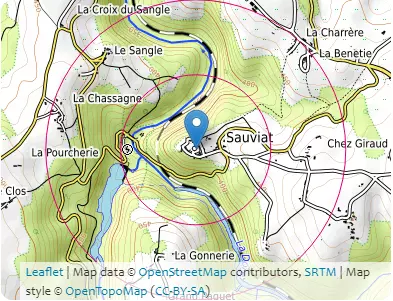
| Distances / Direction | At the place of construction | 500m | 1000m |
|---|---|---|---|
| North | 436 m | 360m | 407m |
| Northeast | 405m | 465m | |
| East | 456m | 473m | |
| Southeast | 419m | 446m | |
| South | 449m | 476m | |
| Southwest | 432m | 411m | |
| West | 360m | 468m | |
| Northwest | 403m | 452m |
B3 – Building
- Type of building: monumental building
- Design working life category: 100 years
- Max height: 15.0 m
- Orientation from North: 80°
B4 – Terrain categories
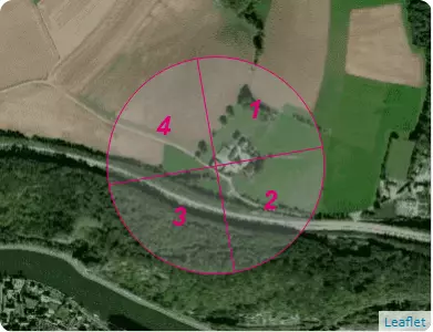
| Sectors | 1 | 2 | 3 | 4 |
|---|---|---|---|---|
| Categories | IIIa | IV | IV | IV |
C1 – Snow
NF EN 1991-1-3/NA (may 2007) + A1 (july 2011)
- Zone : A2(sk,0 = 0.45 kN/m²)
- Criteria for zoning : PUY-DE-DOME (63)
- Characteristic value of snow on the ground at the relevant site : sk,436 = 0.686 kN/m²
- Ground snow load with a return period of 100 years : s100 ans = 0.774 kN/m²
- Design value of exceptional snow load on the ground : sad = 1.0 kN/m²
C2 – Vent
NF EN 1991-1-4/NA (march 2008) + A1 (july 2011) + A2 (september 2012) + A3 (april 2019)
- Zone : 2(vb,0 = 24.0 m/s)
- Criteria for zoning : PUY-DE-DOME (63)
- Zone cdir : 1
| Sectors | 1 | 2 | 3 | 4 |
|---|---|---|---|---|
| Sector definition | from 35 ° to 125 ° | from 125 ° to 215 ° | from 215 ° to 305 ° | from 305 ° to 35 ° |
| Fundamental value of the basic wind velocity vb,0 | 24.0m/s | |||
| Shape parameter K | 0.2 | |||
| Exponent n | 0.5 | |||
| Annual probability of exceedence p | 0.01 | |||
| Probability factor cprob | 1.038 | |||
| Directional factor cdir | 0.7 | 1.0 | 1.0 | 1.0 |
| Basic wind velocity vb | 17.4m/s | 24.9m/s | 24.9m/s | 24.9m/s |
| Reference roughness length z0,II | 0.05m | |||
| Roughness length z0 | 0.2m | 1.0m | 1.0m | 1.0m |
| Terrain factor kr | 0.209 | 0.234 | 0.234 | 0.234 |
| Height above ground z | 15.0m | |||
| Minimum height zmin | 5.0m | 15.0m | 15.0m | 15.0m |
| Roughness factor cr(z) | 0.904 | 0.635 | 0.635 | 0.635 |
| Orography factor * co(z) | 1.0 | 1.0 | 1.0 | 1.0 |
| Mean wind velocity vm(z) | 15.8m/s | 15.8m/s | 15.8m/s | 15.8m/s |
| Turbulence factor kl | 0.97 | 0.854 | 0.854 | 0.854 |
| Standard deviation of the turbulence σv | 3.544m/s | 4.989m/s | 4.989m/s | 4.989m/s |
| Turbulence intensity Iv(z) | 0.225 | 0.315 | 0.315 | 0.315 |
| Air density ρ | 1.225kg/m3 | |||
| Exposure factor ce(z) | 2.102 | 1.292 | 1.292 | 1.292 |
| Peak velocity pressure qp(z) | 392.0N/m2 | 491.5N/m2 | 491.5N/m2 | 491.5N/m2 |
| Peak wind velocity for Serviceability Limit States vp(z),SLS | 91.1km/h | 102.0km/h | 102.0km/h | 102.0km/h |
| Peak wind velocity for Ultimate Limit States vp(z),ULS | 111.5km/h | 124.9km/h | 124.9km/h | 124.9km/h |
Here, the orography factor is calculated according to Procedure 1, for an orography consisting of obstacles of various heights and shapes. This type of orography is the most frequently encountered.However, if the building is in a case of orography consisting of well individualized obstacle (isolated hills and ridges or cliffs and escarpments) the orography factor must be calculated according to the procedure 2. According to EN 1991-1-4 §4.3.3(1), the calculated orography factor (1.018) is not taken into account because it does not increase wind velocities by more than 5%%.
C3 – Seism
Code of the Environment – Article D563-8-1 (09/01/2015)
JORF n°0248 du 24/10/2010 texte N°5
- Zone : 3(1.1 m/s²)
- Criteria for zoning : Sauviat, Puy-de-Dome (63)
- A seismic analysis may be required for this building.