What is the orography factor for ?
The wind velocity is different depending on whether the building is on a terrain with no slope, a hill or a cliff; the orography factor is used to model the influence of the relief on the exposure factor.
How to calculate the orography factor ?
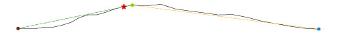
The general procedure, given in Eurocode 1 part 1-4 §A.3, is applicable for a well individualized obstacle (an emergent zone compared to a general ground without marked relief).
It takes into account the slope of the terrain that the wind follows and the position of the building in relation to the top of the hill or the crest of the escarpment. The windward terrain can be considered up to a distance of 10 times the height of the isolated orographic element.
When the orography increases wind velocity by more than 5%, it is recommended to consider the effects using the orography factor c0
The effect of orography may be neglected when the average slope of the terrain in the wind is less than 3°.
The French national annex offers an additional procedure called « complex orography »:
\[\displaystyle c_{o(z)} = 1 + 0.004 \cdot \left( A_{c} – A_{m} \right) \cdot e^{-0.014 \cdot \max{(0, z – 10)}}\]This is applicable in all circumstances and consists in comparing the altitude of the construction site Ac with altitudes Ai in several directions at distances of 500m and 1000m:
\[\displaystyle A_{m} = \frac{2 \cdot A_{c} + \sum_{i} \left( A_{i,500} + A_{i,1000} \right)}{10}\]The orography factor resulting from this operation is valid if it is not greater than 1.15, otherwise it is very likely that the building is facing a marked relief falling under the general procedure.
How to get the elevation data ?
Many solutions (but the last one is really effective !) :
- You can use topographic maps, old fashioned!
- You can use specialized sites to provide altitudes based on a GPS point like Maps&Directions or software like Google Earth, but it remains tedious when it is necessary to get several altitudes at precise distances.
- I advise you rather to try Eurocodes Zoning which is capable of automatically calculating the orography factor according to the procedure adapted to your case.
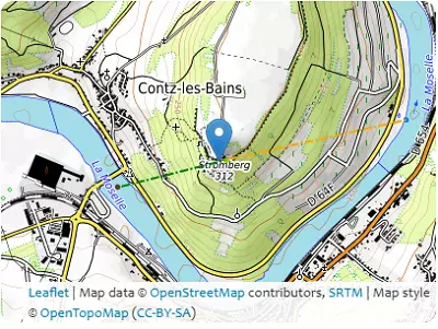
| Coordinates | 6.3473°, 49.4484° | 6.356°, 49.4498° | 6.356°, 49.4498° | 6.3703°, 49.4519° |
|---|---|---|---|---|
| Elevations | 149m | 285m | 285m | 145m |
| Obstacle effective height H | 136m | 140m | ||
| Slope actual length Lu / Ld | 650.1m | 1061.6m | ||
| Slope angle Φ | 20.9% | 13.2% | ||
| Horizontal distance site/top x | 47.8m | |||
| At the place of construction | 275m | |||